Gwynedd Archaeological Trust
Regional Historic Environment Record

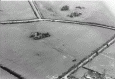
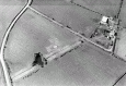
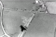
Standing Stone, Llys Einion, South-West of Maen Chwyf

Primary Reference Number (PRN) : 2103
Trust : Gwynedd
Community : Rhosybol
Unitary authority : Ynys Mon
NGR : SH42998585
Site Type (preferred type first) : BRONZE AGE STANDING STONE
Status : Scheduled Monument

Summary :
Llys Einion standing stone is located to the north-west of the possible burial chamber of Maen Chwyf. It is quite small in size, measuring only 1.6m in height, and a width varying between 0.6m at the base to 1m at the top.

There is a groove running down the north side of the stone, which is a feature also noted on some stones on the Llyn peninsula. It has been suggested that these marks may the result of lightning striking the stones.

An alternative interpretation of the Llys Einion stone is that it is actually a cattle rubbing stone. There is some erosion around the base, and it is located in the centre of a field.

Description :
Maen Hir, about one mile west and south-west of Maen Chwyf Church. 5.5ft high by 3.5ft wide by 2 1/4ft thick. (RCAHMW, 1937)

Standing stone 1.8m high, 0.8m thick and 1.0m wide. <2>

A small standing stone 1.6m high by 1.0m by 0.6m at its base. The ground surface is badly worn away around its base to a depth of about 0.2m <3>

Site as described. The ground around the base of the stone continues to be worn away by grazing animals. Stone may need possible protection. <4>

As described: There is a groove down the N side of the stone and a longitudinal crack down the E side. The field boundary to the N has been removed. <6>

A fairly small, neatly shaped stone. Its position in the centre of the field makes it possible that it was set up as a rubbing stone. The shallow 'groove' in the north side is interesting as a similar feature has been noted in 2 stones in Llyn. Could it be lightning tracking? (Smith, 2003)

Sources :
Cooke, N. , 2014 , Rhyd-y-Groes Repower, Anglesey: Cultural Heritage Assessment. ( © Wessex Archaeology)
Dickson, C. & Tram, N. , 2015 , Stone, Hilltops, Water and the Sun: A Preliminary Investigation into the Orientations of Standing Stones Near the River Alaw, Anglesey , Archaeology in Wales : Vol. 54 : p. 43-52
Hadley, A. , 2016 , Proposed Wind Turbine at Nant-y-fran, Cemaes, Isles of Anglesey. Cultural Heritage Impact Assessment. ( © Archaeology Wales)
Smith, G. , 2003 , Prehistoric Funerary and Ritual Monument Survey: West Gwynedd and Anglesey ( © GAT)
Smith, G., and Steele, N. , 2005 , Pan-Wales Prehistoric Funerary and Ritual Sites Survey: Trial Data Synthesis ( © GAT)
The Royal Commission on the Ancient and Historical Monuments of Wales , 1937 , An Inventory of the Ancient Monuments in Anglesey
Ordnance Survey , 1970 , SH48NW 4 , <2>
Harkness, M. D. , 1987 , PRN 2103 , <4>
Lynch, F. , 1970 , Prehistoric Anglesey , <5>

Events :
42242 : An 077 Fmw Site Visit (year : 1986)
42243 : An 077 Fmw Site Visit (year : 1992)
42244 : Prn 2103 Gat Site Visit (year : 1987)
40526 : Prehistoric Funerary and Ritual Monument Survey: West Gwynedd/Anglesey (year : 2003)
45013 : Rhyd-y-Groes Repower, Anglesey: Cultural Heritage Assessment. (year : 2014)
40527 : Pan-wales Prehistoric Funerary and Ritual Sites Survey: Trial Data Synthesis (year : 2005)
45130 : Proposed Wind Turbine at Nant-y-fran, Cemaes, Isle of Anglesey. Cultural Heritage Impact Assessment. (year : 2016)

Related records

Compiled date : 16-12-1986


Images :


The above data are supplied by GAT in partnership with its Local Authorities (Anglesey, Conwy and Gwynedd County Councils, and Snowdonia National Park Authority), © GAT 2025 (and in part © Crown, 2025 - as indicated)
This information is supplied for the purposes of personal interest only and may not be used as part of a commercial project.

March 29, 2025, 1:57 am - HTML file produced from Gwynedd Archaeological Trust Regional HER
Gwynedd Archaeological Trust, Craig Beuno, Garth Road, Bangor, Gwynedd.  LL57 2RT
tel (01248) 352535,  fax (01248) 370925, email her@heneb.co.uk, web www.heneb.co.uk