Gwynedd Archaeological
Trust Regional Historic Environment Record
Roman Fort, Remains of, Holyhead
Primary Reference Number (PRN) : 1762 Trust : Gwynedd Community : Holyhead Unitary authority : Ynys Mon NGR : SH24718262 Site Type (preferred type first) : ROMAN FORT Status : Scheduled Monument , Cared for by the State
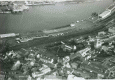
Summary : All that remains of the Roman Fort at Holyhead is a Roman wall enclosing St Cybi's Church and churchyard. The enclosure is rectangular measuring c.76m x 50m, oriented north south and would have had a circular tower at each corner. The original wall survives on the north, south and west sides but has been partially obscured by modern housing. It is nearly 2m thick in places and built of cemented rubble faced with dressed stones. The fort is interpreted as a small coastguard fort of the late Roman period.
Description : Roman fort. <1>
Caer Gybi. A three sided rectangular walled enclosure, the fourth side being formed by a steep cliff of rock, c.15ft high. Within the enclosure lies the parish church of Holyhead. The walls have traces of a parapet walk and round towers at the four corners. In July 1952 W.E. Griffiths carried out a brief evaluation on behalf of the Ministry of Works. There was no trace of a ditch, see plan. (RCAHMW, 1937) <3><4>
For sometime Caer Gybi has been classified as a late Roman fort <5> (though there has always been an element of doubt) but Richmond compares the site with the fortified ship landings or beach points detected by Dr. Schleiermacher on the Rhine and they are at least dated to the last quarter of the 4th Century. These structures had three fortified sides only, the fourth side, on the water front, being open and secured solely from flank attacks by walls which went down to low water level and ended in towers. <6>
Published survey 25" revised. <7>
Condition unchanged. <8>
The part of the fort on top of the cliff measures 0.32 hectares; the extent of the sea shore part being unknown. The West Side measures 75.5m and the North and South sides 48 and 41m respectively to he points at which they disappear on the cliff. No datable finds are known, but from the style of building and its position Caer Gybi clearly belongs to the coastal fortifications of the 3rd and 4th Centuries such as Cardiff. No similar example of a three-sided landing place is known in Britain, but examples on the Rhine frontier are dated to the reign of Valentinian. Caer Gybi is unlikely to be earlier and may be assignable to the reorganisation of Britain under Count Theodosius. <9>
SMC Correspondence in FI file.
As mentioned in the Scheduling document the fort would likely have been one element within a more extensive system of coastal defences along the north coast of Anglesey. In his investigation of this hypothesis Crew (1981: 35) writes “The field of view from Holyhead Mountain and Pen Bryn yr Eglwys encompasses a substantial proportion of the Irish Sea and Liverpool Bay and it is feasible that these two watch towers together with Caer Gybi, formed an independent element in the defences of the west coastline. However, the intriguing possibility arises that there may have been a more comprehensive system along the North Wales coast, linking to Chester” (Rees & Jones 2017).
Placed in the guardianship of the Ministry of Works, Ancient Monuments Branch in 1948. (Roman Wall) (Arch Cam Vol. C, 1949).
An account Cambrian Archaeological Association’s visit to the site in August 1870 with discussion. (Griffith 1870).
Investigation as to possibility of a trench outside the North wall and examination of the North-West Tower. Investigations in 1952 possible because of house clearances (Griffiths, 1954).