Gwynedd Archaeological
Trust Regional Historic Environment Record
Caer y Twr Hillfort, Holyhead Mountain
Primary Reference Number (PRN) : 1760 Trust : Gwynedd Community : Trearddur Unitary authority : Ynys Mon NGR : SH218830 Site Type (preferred type first) : PREHISTORIC HILLFORT Status : Scheduled Monument , Cared for by the State
Summary : Caer y Twr, on the summit of Holyhead Mountain covers an area of around 7 hectares and is one of the largest of its kind in North Wales. It consists of a single stone rampart, surviving in places to a height of 3m with an inner and outer face of massive masonry and a rubble core. The entrance is at the north-east corner. A wide breach in the wall on the north side appears to have been a deliberate slighting and may have occurred during the Roman period when a small watchtower was also built on the western summit, covering a cairn, presumably of Bronze Age date.
There are no visible remains of huts within the enclosed area but it is likely that the fort is associated with the neighbouring hut circle settlements at Ty Mawr and elsewhere.
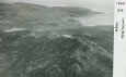
Description : Caer y Twr hillfort crowns the summit of Holyhead Mountain and covers c.17 acres (larger than most in N. Wales): it consists of a single stone rampart wall occurring around 575-650ft levels. On the SE and SW sides, the defences are natural sheer precipices etc. Rampart is dry built and in good condition on N and E sides, and utilises the natural features of the ground: no indication of an external ditch. Where best preserved (on N side) it is 13ft wide at the base and a maximum height of 10ft with a batter on either side. On N side too there survives a stretch of rampart walk c.4ft wide and 3-4ft above ground level, above which, on the outer side, are the remains of a breast-work. (Rampart walk is also prepared on E side and was presumably continuous.) One original entrance in NE corner, of in-curved type with well built walls on either side, c.10ft wide. There is a wide breach in the N rampart, and material is still by the rampart. No hut-sites can be identified within the fort, but possible terraces outside the NW corner. Condition: good: stones have been cleared from outer face of rampart. (RCAHMW, 1937)
1969 - Condition unchanged <2>
Description. Photographs of the ramparts and cross-sectional plans. <3>
A large hillfort defended by natural cliffs on two sides and by a substantial faced stone wall on the rest. There is a single entrance at the north-east where the enclosure wall is in-turned to create a passageway. There is no evidence that there were ever any internal buildings despite the large area enclosed. The only finds have been a small hoard of late Roman coins but these are associated with a watch tower/signal station on the summit. There is also an extensive settlement of Roman-period roundhouses at Ty Mawr to the south-west of the fort. (Smith, 2005)
The hilltop was burnt off in 2004 removing the dense cover of gorse and heather. This has made nearly all the interior of the fort completely visible. However, despite a good walkover no new features such as enclosures or round huts could be seen or even any areas that looked like they may have been cleared or levelled. The previous descriptions by the RCAHMW and F.M. Lynch still stand. (Smith, 2005)
Report on the hill fort at Caer y Twr. Includes maps and illustrations (Gardner 1934).
Referenced as comparison example in article on Cliff Castles (Barnwell, 1875).
Events : 42159 : Caer Y Twr Full Survey (year : 1937) 40621 : Prehistoric Defended Enclosures in North-west Wales, 2004-5: West Conwy, Gwynedd (Arfon) and Anglesey (year : 2005) 44557 : Early Celtic Societies in North Wales (year : 2010) 45042 : Iron Age Settlements in Wales: Cadw Defended Enclosures Publication. Hillforts and Hut Groups in North-West Wales. (year : 2008) 40620 : Prehistoric Defended Enclosures: Scoping for Pan-Wales Assessment (year : 2003)