Gwynedd Archaeological
Trust Regional Historic Environment Record
Hut Circles, Holyhead Mountain
Primary Reference Number (PRN) : 1755 Trust : Gwynedd Community : Trearddur Unitary authority : Ynys Mon NGR : SH212820 Site Type (preferred type first) : PREHISTORIC HUT CIRCLE SETTLEMENT Status : Scheduled Monument , Cared for by the State
Summary : The hut circle settlement at Ty Mawr near South Stack, Holyhead was first investigated by W.O. Stanley between 1862 and 1868. He interpreted the site as belonging to the Roman period, based on the discovery of 12 Roman coins in one of the huts. Modern excavations by Christopher Smith in 1978-82 showed evidence of intermittent human occupation of the area from the Mesolithic period through to the 6th century AD, however. The circular huts and rectangular workshops/ancillary buildings are not the remains of a single settlement but a series of farmsteads of various dates. In addition to the Roman coins found in the 19th century, finds from the site included flints, a stone mortar, slag and crushed quartz.
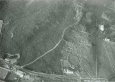
Description : Near Ty Mawr, large hut group on natural terrace on SW slope of Holyhead Mountain, just above and following 300ft contour. The remaining lies just above the limit of cultivated ground, but many are known to have been destroyed by cultivation: in 1865 over 50 were recorded and partial destruction of many others noted: now c.20 remains (1937). Partially excavated By Stanley in 1862. <1>
Some huts were cleared by Ministry of Works after their assumption of the guardianship of the site in 1911. Settlement now (1937) c.480 yards in length (though it is known to have been c.800 yards.) x 150yrds, comprising of an area of 15-20 acres). Main group of 14 huts lies in the SW end of the site. The structures are of two main types- circular huts and small sub rectangular chambers, and not arranged in any definite plan, although a road running east to west is discernible (A-O). Some huts had hearths, drains, floors and passages. The NE part of the site (huts R-X) consists of 5 scattered circular huts and a much ruined oblong chamber. Also a series of cultivation terraces (see PRN 1756). <1> <2> (RCAHMW, 1937)
Described as in good condition: huts having been cleared and restored. Condition unchanged 1969. <4>
Excavations began again 1978-82 by C. Smith, to investigate structures not done in C19 and to examine nature of field system. (Smith, 1978)
Work in 1979 established that some of the hut circles were part of a pre Roman enclosed hut- group; at least two phases of development beginning in late Neolithic/EBA. Finds include barbed and tanged arrowhead, part of a stone axe and several sherds of coarse hand made pottery. (Smith, 1979)
1980 further evidence of phasing (a single circular building with small enclosure, superseded by larger building and enclosure): both phases probably prehistoric, occupation being represented by stone tools. Partial reconnaissance work also began. <7>
1981, building S excavated for third time (1868 + 1913). Midden examined and possible new buildings discovered. (Smith, 1981)
No evidence to suggest Roman occupation of the sites dug (and possible entire settlement). Finds have consistently implied a Neolithic date and partly confirmed by two C14 dates 1940 + 80 BC (HAR 4695): so activity appears to have centred on latter part of 3rd millennium BC. (Smith, 1982)
The restoration work (and accompanying finds and archaeological observations) of 1912-13 has been published and analysed by Smith. <10> (See also for bronze hoard found whilst removing one of the huts in 1867).
Old HER refers to "restoration" in 1912, by A. Trowbridge, office O.O.W. (Office of Works?). No further information or supporting bibliographic reference given. <17>
Part of this site was initially excavated by W.O. Stanley (1867) when at least twelve roundhouses were explored. This unusually large, although undoubtedly multi-phase, site consists of over fifty round and rectangular buildings which are scattered across terraced field systems which are partially defined by low field walls. The site covers an area of some 16ha (C. Smith 1985, 42).
The main group of buildings consisted of a concentration of 14 roundhouses lying at the south-western limits of the site, associated with a trackway running east to west. Some of the buildings were oblong in shape and their function was difficult to ascertain, and appropriate parallels have proved difficult to find elsewhere (C. Smith 1984, 64). Stanleys excavations identified hearths, occupation floors and finds assemblages within the stone roundhouses (1876). This included typical later prehistoric stone artefacts as well as Roman coins and coarse pottery. The Roman material was originally used to date the site, although it is now accepted that many of the roundhouses were probably first occupied in the Iron Age period. The remains of other badly ploughed-out buildings were also identified by Stanley (1867, 232).
This site was subsequently excavated in 1912 by the Office of Works which undertook a programme of clearance, survey and recording (C. Smith 1984, 65). This work entailed the partial excavation and recording of over eighteen buildings in the settlement here, a number of construction and occupation contexts within buildings were observed, such as stone-faced walls, drains and hearths, and finds such as spindlewhorls, whetstones, querns and sling stones were recovered. Some of the details of this work have since been published by Christopher Smith (1984) in the form of edited site notes, finds tables and sketches. The site has remained open to the public since 1913. :: This settlement was first excavated by W.O. Stanley (1867) as part of his investigations into the Holyhead Mountain scattered stone roundhouse settlements (AN68), which are located immediately to the west. The enclosure was excavated again in the late 1970s and early 1980s by Christopher Smith (1984; 1985; 1986; 1987). The settlement consists of a stone curvilinear enclosure with two internal roundhouses (S and T1). An isolated roundhouse (T3) is located just outside the enclosure (Figure 6.19). The settlement is associated with a terraced field system. Stanley initially explored the large roundhouse (S) within the enclosure, which he found to contain a stone-lined hearth and a possible stone internal partition wall (Stanley 1867, 231). A midden accumulation of limpet and periwinkle shells were found on the floor of this building, which included a saddle quern, two grinding/rubbing-stones and a spindlewhorl (Stanley 1867, 232). Building S was re-excavated by Christopher Smith and these in situ occupation floors were positively identified (1985). The radiocarbon dates from the settlement reveal that it was occupied in the Middle Late Iron Age. A small single roundhouse (T3) just below the settlement was evidently the focus for Roman occupation, and it was revisited again in the fifth and sixth century cal. AD when the decaying building was re-used.
The first evidence for occupation consists of two hearths located within the enclosure. Samples from these features reveal that this phase probably belongs to the late-third and early-second millennium BC (HAR 4694, 28792634 cal. BC; HAR 4695, 24712210 cal, BC) and long before the Iron Age roundhouse settlement was constructed (C. Smith 1987, 24). Two main phases of Iron Age occupation were identified within the enclosure. In phase 1, roundhouse T1 was built and this had a diameter of 5.3m (C. Smith 1985, 16). At the same time, an enclosing wall with orthostats and stone facing was constructed to the east and this abutted and formed a double wall around part of the roundhouse, creating a small yard. Shortly afterwards, a larger roundhouse (S) was constructed and this had a diameter of c. 7m. Both buildings had been created within terraced areas which had been cut into the hillslope and they were constructed from stone-faced walls with earth and rubble cores and entrances facing southeast.
Building T1 contained a patchy occupation floor, consisting of a brown silty deposit with charcoal and carbonized seeds, alongside two phases of hearths and a complex of internal drains. The first hearth consisted of a patch of burnt clay, while the later one was situated within a shallow pit. Building S contained several postholes, stakeholes, hearth-like features and a stone-capped drain, also implying the presence of more than one phase of occupation (C. Smith 1985, 11).
The second phase saw the reconstruction of the entrance to Roundhouse S and, perhaps, the partial demolition of T1, in which an extensive deposit of rubble was dumped on the floor. This phasing of the destruction of T1 is based more on the physical arrangement of the buildings, which were quite close to one another, rather than any stratigraphic relationships, and it is also equally possible that T1 remained in use in this phase. Additional boundary walls were added to the southwest and this created a formal enclosure boundary and it enlarged the settlement space. A number of features were discovered within the newly enlarged enclosure, including an unusual seven-post structure, which probably functioned as a raised granary, as well as a stone-lined storage pit (C. Smith 1985, 32). Finds of animal bone and shell were recovered from the latter feature, and an ephemeral shell midden, originally recorded by Stanley (1867; see above), was found to have accumulated against the wall of Building S and two marine shell samples from this horizon produced dates of 837413 cal. BC (HAR 5403) and 746-401 cal. BC (HAR 5404). Due to the problems in dating marine shells, these dates have been adjusted to c. 28515 bc (Kelly 1990, 104; C. Smith 1987). A large circular pit, c. 1m deep, was also discovered next to the enclosure entranceway. This feature was interpreted as a pond, which was possibly in use in the last phase of occupation (phase 2c; C. Smith 1985, 30).
The settlement was reoccupied in the early medieval period. The original roundhouse (T1) was reoccupied in the early medieval period, when a hearth and two other features were constructed into the rubble infill of this building (C. Smith 1987, 25). Charred plant remains from the floor (17) produced a date of cal. AD 406870 (HAR-7081). The small external roundhouse building (T3) was also explored and found to have been constructed with a stone faced wall with a rubble core. This also produced occupation deposits which were dated to cal. AD 430768 (HAR 5730) and it is suggested that this activity occurred in the sixth century (C. Smith 1985, 367). It is possible that this building was actually built in the early medieval period (see Kelly 1990, fig. 12). Also found scattered around the eastern area of the excavations were the remains of a later oblong building (T4), and three samples of charred plant remains from T4 are broadly contemporary, with calibrated dates of AD 433775 (HAR 5731), AD 138536 (HAR 6684) and AD 415966 (HAR 6803). Based on the radiocarbon dates, the occupation is likely to be confined to the early medieval period. (Waddington 2013)
In the Arch. Camb. for 1868, p. 385, there is an article by the Hon. W. O. Stanley, M.P., On the Remains of Ancient Circular Habitations on Holyhead Island, called Cyttiau'r Gwyddelod, at Ty Mawr, on the South-West Side of Holyhead Mountain."" Through the kindness of the present Lord Stanley of Alderley, the writer had an opportunity, in November, 1906, of seeing some of these hut-circles and the objects dis- covered in them. The excavations are described with great care and thoroughness, and the article should be read in its entirety by all who are interested in the conditions of the life of early man in Anglesey. At Ty Mawr there are more than fifty huts. Mr. Stanley states that in these huts no fragments of pottery or iron were found. In 1830, the tenant of Ty Mawr Farm, Hugh Hughes, on removing some of the large stones near the huts, found underneath them a considerable number of bronze spear-heads of different forms and sizes also well-formed bronze celts, axe-shaped and socketed, with rings of various sizes, armlets and many red amber beads.(Annwyl, 1908).
Chronology and Discussion of the Hut Circles at Ty Mawr (Smith, 1987).
Description, illustration and maps of the hut settlement on Holyhead Mountain (Stanley, 1868).
Description and illustration of “relics” found in the hut settlement on Holyhead Mountain (Way, 1868).
A detailed account of finds from the excavation with reports from individual specialists John Conway, John Evans, Vivian Evans, Helen Keeley and Dorian Williams (Smith 1986).
Excavations at Ty Mawr Hut Circles, Holyhead, Anglesey ( Part 2 ) (Smith, 1985).
Sources :
Barnwell, E. L. , 1881 , Querns
Grant, F. , 2016 , Unmanned Sites Interpretation Installations - Watching Brief Report. CN006 Segontium Roman Site, AN011 Trefignath Burial Chamber, AN016 Holyhead Mountain Hut Circles
Smith, C. , 1978 , Hut Circles, Holyhead Mountain , Archaeology in Wales : Vol. 18 : p. 30
Smith, C. , 1979 , Further Examination, Holyhead Mountain Hut Circles , Archaeology in Wales : Vol. 19 : p. 9
Smith, C. , 1981 , Investigation, Hut Circles, Holyhead Mountain , Archaeology in Wales : Vol. 21 : p. 19-20
Smith, C. , 1982 , Holyhead Mountain Hut Circles , Archaeology in Wales : Vol. 22 : p.13
Smith, C. , 1985 , Excavations at Ty Mawr Hut Circles, Holyhead, Anglesey
Smith, C. , 1986 , Excavations at the Ty Mawr Hut-circles, Holyhead, Anglesey Part III: The Finds
Smith, C. , 1987 , Excavations at the Ty Mawr Hut-circles, Holyhead, Anglesey
Stanley, W. , 1868 , On the Remains of Ancient Circular Habitations in Holyhead Island
The Royal Commission on the Ancient and Historical Monuments of Wales , 1937 , An Inventory of the Ancient Monuments in Anglesey
Waddington, K. , 2010 , Early Celtic Societies in North Wales
Waddington, K. , 2010 , Early Celtic Societies in North Wales
Waddington, K. , 2013 , The Settlements of Northwest Wales: From the Late Bronze Age to the Early Medieval Period
Waddington, K. , 2013 , The Settlements of Northwest Wales: From the Late Bronze Age to the Early Medieval Period
Way, A. , 1868 , Relics found In and Near Ancient Circular Habitation in Holyhead Island
Stanley, W. O. , 1867 , Archaeological Journal , <1>
Stanley, W. O. , 1869 , Archaeological Journal , <2>
Ordnance Survey , 1969 , SH28SW 2 , <4>
Smith, C. , 1980 , Archaeology in Wales , <7>
Smith, C. , 1984 , Archaeologia Cambrensis , <10>
Smith, G. , 1998 , Hut Circle Settlement Survey , <12>
Lynch, F. , 2009 , Anglesey Past Landscapes of the Coast , <16>
Steele, N. , 2009 , PRN 1755 , <17>
Griffiths, W. E. , 1951 , Antiquity , <18>
Longley, D. & Yates, M. , 2001 , Anglesey: A Guide to Ancient Monuments on the Isle of Anglesey , <19>
Driver, T. , 2005 , PRN 1755 , <20>
Events : 42151 : On the Remains of the Ancient Circle Habitations in Holyhead Island Called Cyttiau’r Gwyddelod at Ty Mawr (1) (year : 1862) 42152 : On the Remains of the Ancient Circle Habitations in Holyhead Island Called Cyttiau’r Gwyddelod at Ty Mawr (2) (year : 1868) 42153 : Holyhead Mountain Hut Circles, Holyhead (year : 1978) 42154 : Holyhead Mountain Hut Circles, Holyhead (year : 1980) 42155 : Holyhead Mountain Hut Circles, Holyhead (year : 1979) 42156 : Holyhead Mountain Hut Circles, Holyhead (year : 1980) 42157 : Holyhead Mountain Hut Circles, Holyhead (year : 1981) 42158 : Holyhead Mountain Hut Circles, Holyhead (year : 1982) 40782 : Hut Circle Settlement Survey (year : 1998) 44557 : Early Celtic Societies in North Wales (year : 2010) 44557 : Early Celtic Societies in North Wales (year : 2010) 45272 : Unmanned Sites Interpretation Installations - Watching Brief Report. CN006 Segontium Roman Site, AN011 Trefignath Burial Chamber, AN016 Holyhead Mountain Hut Circles (year : 2016)