Gwynedd Archaeological
Trust Regional Historic Environment Record
Copper Mine, Great Orme
Primary Reference Number (PRN) : 1694 Trust : Gwynedd Community : Llandudno Unitary authority : Conwy NGR : SH77078308 Site Type (preferred type first) : PREHISTORIC COPPER MINE Status : Scheduled Monument
Summary : The Bronze Age workings at the Great Orme copper mines include both underground galleries and opencast surface workings where the ore was removed from the soft host rock using hammerstones and bone and antler tools. Radiocarbon dates suggest that the surface workings are the oldest with dates around 1600 BC. The mines were also worked in the 19th century and the spoil from these later operations obscured and to some extent protected the prehistoric remains. In fact, miners in the 19th century reported cutting through earlier galleries which were, at that time, assumed to be Roman.
The main activity at the Great Orme mines dates to the middle Bronze Age, a time when the Welsh industry was flourishing. Despite this, to date no evidence of any large scale smelting on the Great Orme has been found. Neither do we know whether the mining was done by people living locally or by itinerant workers as no traces of associated settlement have been found.
Description : Excavations on the Vivian shaft on the Great Orme uncovered traces of prehistoric (Bronze Age) copper working. The excavation report is in progress. Site directed by L. A. Dutton (Lewis 1988).
Report on 1990 season (Lewis 1990). Report on 1991 season <8> Report on 1989 season (Lewis 1989) <11>
Great Orme, Excavation Management, Llandudno (SH 771 831). Surface excavations continued at the Great Orme Bronze Age copper mines visitor site throughout the spring and summer of 1991 managed by Gwynedd Archaeological Trust. The excavations have provided an important and integral part of the interpretation and attraction of the overall site as a Bronze Age Mining Centre. The surface excavations closed for the season at the end of September and will continue in the spring of 2002.
The site is a logical extension to the area investigated by the trust during 1988/ 89 and has revealed a variety of new aspects relating to the exploitation of copper ores throughout the prehistoric period. Of particular note is the presence of a narrow prehistoric shaft that has provided the most well- preserved, complete and undisturbed evidence of working with bone tools in altered dolomite, and the remains of part of an enigmatic drystone structure associated with the shaft head. L.Dutton, Gwynedd Archaeological Trust. <9>
Great Orme Bronze Age mine, Llandudno (SH 771 831). During the winter of 1991 the Gwynedd Archaeological Trust maintained a watching brief on the site of the bronze age copper mines on the Great Orme, Llandudno (on behalf of Great Orme Mines Ltd) during the removal and redistribution by machine of surface mining waste in the general vicinity of Vivians Shaft. Archaeological recording during this operation was mainly by way of photograph and annotated sketch plans and sections, orientated and supplemented by tape survey utilising the surviving site grid from the Vivians Shaft excavation of 1989.
Some 60,000 tonnes of waste material was removed over a three month period, revealing the rock surfaces of an extensive open cast working of the prehistoric period. Traces of revetting within areas of spoil were observed. A number of features associated with localised areas of working were revealed and recorded in the sides of the opencast, including undisturbed cashes of bone and stone tools. A report on the findings was submitted to Great Orme Mines Ltd on completion of the work. L.Dutton, Gwynedd Archaeological Trust. <8>
Scheduled Ancient Monument: Cn 216 <15>
No evidence has been found of Roman mining activity on the Great Orme to date. This is a popular misconception based on spurious evidence. <32>
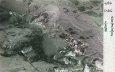
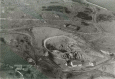
The Great Orme Copper Mines above Llandudno have an extensive complex of surface and underground workings exploiting copper ores in soft, easily worked strata. The true extent of mining operations here is unknown but it is believed to exceed 24,000 square metres, incorporating passages totalling more than five kilometres and penetrating a depth of seventy metres. (Gwyn and Davidson, 2012)
A radio-carbon date has been obtained from charcoal, which was mixed with waste country rock and vein-stuff, stacked on a ledge in Gallery B, about 25m below the surface. This material is probably debris from fire-setting. The date of 990 +- 80 bc (HAR-4845) indicates that the mine was being exploited during the late Bronze Age. (James 1985)
Report on excavations at the copper mines on the Great Orme, including illustrations of finds (Davies, 1949).
During 1991 in the corse of clearing some of the underground workings east of Vivian's Shaft, ata about 20m depth below surface, a hitherto unexplored passage, some 8m long, was found. This bore all the hallmarks of untouched bronze age workmanship - very low and narrow entrance, irregular cross-section, and an abssence of drill-holes and pick-marks - except for a small area at the far end which was clearly the result of 18th/19th century reworking.
Preliminart exploration brought to light a deposit of charcoal in one of the crevices in the side wall, and a sample from this later produced a Carbon 14 date of 3000 50BP (BM2641) = 1410-1070 Cal BC. Also, in the loose sediment forming the floor, he found two very small fragments of metal, one of which was later analysed by the British Museum as bronze, with a composition characteristic of the M2 middle bronze age group (Tylecote, 1986).
A systematic excavation was carried out during the winter of 1991/92, in the hope of finding further evidence of bronze age working. All material excavated from the passage was sieved and a metal detector then passed over it. Some 80 very small fragments of metal were recovered, two of which have been analysed and found to consist of arsenical bronze. All of these fragments were less than 2cm in length, and all were jagged in shape, suggesting it had been shattered by some force unknown.
Much charcoal was also found, also 3 stone mauls and 4 fragments of bone tools.
There are still 2m of mixed spoil and sediment overlying the rock floor of this passage (David 1992).
During 1994, excavations were carried out in an area about 10m square immediately to the south of the 19th century Vivian's shaft. These confirmed the existence of two Bronze Age workings which followed the line of two veins running north-south. The larger of these two, the 'Central Vein', varies from 1m to 2m wide and is cut by Vivian's shaft; the smaller one, the 'West 1 Vein', is mostly less that 1m wide and is separated from the Central Vein by a rib of dolomitised limestone between 1m and 2m wide.
Both workings appear to terminate about 1m north of the southern edge of the excavation, inline with the edge of the prehistoric cliff on the north side of the spoil-filled Pyllau Valley. Exploration underground immediately underneath this area suggests that this cliff edge extends at least 10m below the present ground surface.
Some 1747 pieces of bone were found, including several almost complete tools showing marks, and six complete stone hammers or mauls. Probable bone tool marks were found in the in the rotted dolomitised limestone adhering to the side of a small aclove off the west side of the Central Vein.
Excavations along the southern edge of the area revealed, below 1m thickness of modern deposits, a series of alternating layers of clayey silt, possibly buried turf layers, and shattered angular boulders, possibly tip lines resulting from 'modern' (17th-19th century) shaft-sinking. The lowest silt layer rests directly on the bedrock, and all layers dip steeply south, towards the centre of the Pyllau Valley. At the eastern end a mass of large angular boulders was found, forming a rough foundation; and lying against gravel, provisionally identified as 'washings' from 19th century ore treatment. Several pieces of Buckley ware have been found in these southern contexts, and it is hoped to obtain dates for some of these iin due course.
During August, the mine was visited by Dr Paul Ambert, the French archaeologist who has been in charge of the excavations at the Early Bronze copper mines at Cabrières (Hérault) in the south of France, and useful exchanges of information were made. (David, 1994)
During the 1997 excavation, a total of 373 fragments of bone were found, including 49 tools or parts of tools, and 6 stone mauls. Of these bone fragments, the largest number (106, or 28% of the whole) were found in three separate mixed strata which had been interpreted as the products of roof collapse, and therefore not in their primary context. The next largest number (65, or 17%) came from one small area in the bottom of the westernmost passage (Passage A), believed to be an undisturbed deposit. Of the stone mauls, four were found near the bottom of the easternmost passage (Passage D), but the remaining two were found in the main collapse layer mentioned above, and therefore out of context.
Some support for the theory of roof-collapse mentioned earlier has come from the discovery of several holes, believed to be artificial, in the vertical wall of dolomitised limestone which forms the east side of this excavation. All of these holes lie approximately on the same level as the top of this wide bedrock, about 2m to the west, which bisects the area from north to south. So they could have stemple-holes, designed to take the ends of horizontal timbers for supporting a platform enabling the miners to stope upwards when following the vein. However, barely 1m above the level of the stemple holes, the rock type changes from massive dolomitised limestone to thin alternating layers of shale and mudstone (both very much weaker rocks) and any upward stoping there could well have caused the roof to collapse.
Also the nature of some of the collapse material is significant; for example a large boulder was found consisting of at least six thin parallel slabs of alternating shale and mudstone. These were all stuck together as in their natural state. but were now lying with their bedding planes dipping northward at a much steeper angle than the very similar beds of the same types of rock forming part of the cliff 4m above (David 1997).
During the Christmas and New Year holiday a large rock fell at the northern end of the East 6 Vein (North), and when we returned to work in Janurary it was obvious that further rock falls were likely. This forced us to abandon further excavation in the area, at least for the time being, and we transferred our attention to a new area above the north-west corner of the Great Opencast. A trial sondage had been excavated here in 1993 by CA Lewis, uncovering the top of a possible bronze-age shaft, but the surrounding rock was so shattered that further excavation was considered too dangerous and the site was covered over again.
Between January and August 1998, an area of some 11m north-south and 15m east-west was cleraed in this new 'north-west corner', revealing a large outcrop of limestone cap rock, and beneath a layer of dolomitised limestone containing several small passages. The first of these (Passage A) runs north for about 2m, then turns north-west to emerge into the daylight on the west side of the outcrop some 3m further on. About 1m beyond the angle in this passage, it is joined by another (Passage B) which runs due south for at least 4m. Unfortunately Passage B was deemed too dangerous to excavate at present, as there is a large crack running the full length of the ceiling, and the limestone cap rock forming the ceiling is so shattered that it cannot be supported with any certainty of safety. Both these passages are believed to be prehistoric; Passage A has bone tool marks on the walls next to the entrance, and in the short distance excavated it produced two stone mauls and 20 fragments of animal bone, more than had been found in the whole of the previous two months. Both passages seem to have escaped the attention of the 19th-century miners whose presence in the area was clearly shown by shot-holes in the limestone cap rock above.
After further clearance of the mainly modern spoil along the east flank of the outcrop, another passage (Passage C) was found at a slightly deeper level, about 1m almost directly below Passage A. Passage C also runs north, but for a much greater distance (at least 14m) and contians more bone tool marks, but further excavation had to be abandoned, again, after two weeks' work, because the rood (here composed of a shale band) was so shattered that it would be unsafe to excavate any further. By this stage, however, it had produced a total of nien stone mauls and 20 fragments of bone (including four probable tools), and a deposit of charcoal.
Because of the problems created by the shattered nature of thr rock throughout the outcrop it was decided at this point to suspend operations in the north-west corner until such time as the limestone cap rock can be removed by machine, possibly next year. Meanwhile, attention was trasferred, once more, to a new area, 'Location 7C West', some 10m south-east of the north-west corner, at the top of the cliff overlooking the south-west corner of the Great Opencast. Here excavation of a trial strip 8m north-south and 3m east-west quickly disclosed the east wall of a deep depression in the rock, probably another another north-south vein, but possibly a larger feature. By the end of the season this had been excavated to a maximum depth of 2m below the previous surface, with no sign of a bedrock floor, or of the opposite (west) wall. Although finds from this new area have so far been comparatively sparse, probably because of the material excavated shows al the signs of being a modern fill, the surface of the rock in the east wall shows several patches of malachite staining, and shallow indentations suggestive of prehistoric mining. Also it directly overlies the area of prehistoric passages, still not completely explored, found in the south-west corner of the Great Opencast in 1993 (see AW 33, 48). A connection with some or all of these from the surface is considered probable, and likewise a connection with the bronze-age shaft ('Shaft 233') found in 1991 some 20m to the south-east (see Dutton and Fasham 1994, 266-8) (Smith, 1998)
During the first six months of 1999 work was continued in the same two areas explored in 1998; the 'north-west corner' of the Great Opencast, and 'Location 7C West' (AW 38, 94-5).
In the north-west corner the shattered rock face which had previously revealed Passages A, B, and C, was cleared of all the mixed (mainly modern) spoil lying against it, right down to the level of the Great Opencast floor. In the process three more passage were discovered, viz:
1) Passage D: a very short level c 1m below Passage C and 1m to the east of it. Probably only a trill, as it extends only 2m northwards before terminating in a narrow pointed end. Almost certainly bronze-age in origin, judging by its narrow cross-section and sinous course, but it produced just two small fragments of animal bone and nothing else of interest.
2) Passage E: an open trench some 3m below Passage D adn 3m to 4m to the east of it. This was found to run c 4m due north into the steep slope of loose spoil which covers the whole north side of the Great Opencast, and beyond this point the rock was so shattered that further exploration had to be abandoned. However, beneath the floor of Passage E and running roughly parallel with it was a second working, accessible only through a very narrow slit in the rock floor of Passage E. This new passage runs northward for c 15m, but then comes to a dead end against a rock'fall. It also runs south from the entrance slit, but this section was not explored as the roof was deemed unsafe.
3) Passage F: another open trench c 4m below Passage E and some 3m to the east of it, within 2m of the Great Opencast flloor. This trench also ran due north for a distance of c 3m, disappearing into an area of very shattered rock at the north-eastern end of the outcrop, and once again exploration had to be abandoned for reasons of safety.
Altogether the finds from the north-west corner this season amounted to 533 fragments of bone, including 48 tools or fragments thereof, and six stone mauls. Of these mauls, four were found lying next to the cliff at the top of the slope (above Passage D) and the other two were found in the mixed spoil at the entrances to Passages E and F respectively. It was noticeable that all the bone fragments were small, and this fact, combined with the nature of the fill (probably equivalent to Type 6, describing in Dutton and Fasham 1994, 257) led us to believe that all three passages had been emptied and refilled with mixed spoil in modern (?19th-century) times. One exception that might be worthy of further exploration is the lower working below Passage E.
In Location 7C West, earth-moving by machine after the end of the 1998 season had removed a mass of mixed spoil up to 3m deep and 3m to 4m wide along the western edge of the rock outcrop. To our surprise, however, there was no sign of a bedrock floor or of the opposite west wall. Either this marks a major geological fault or a hitherto unsuspected extension of the Great Opencast. It is hoped to investigate this further in due course.
On the rock rib east of this depression, attention was concentrated on a deep vein running north to south witin 2m of the western edge of the rib. This new vein has been allocated the number 'West 8'. This was excavated to a depth of c 3m below the bedrock surface on either side, revealing two narrow passages, one above the other, near the bottom, running south-east to connect with the workings in the Great Opencast.
In the course of three months of work, this West 8 vein produced a total of 205 bone fragments, including 43 tools or parts thereof, and five stone mauls. Among the latter was one showing signs of modification by two parallel shallow grooves at right angles to its long axis. This is unusual, as the vast majority of stone mauls from the Great Orme mines are unmodified. Also found were some fragments of charcoal from an undisturbed primary context, and it is hoped to obtain an AMS date from these in due course.
By the beginning of August, work on the north-west corner was suspended. and attention was transferred to a new area, Central Veiin North, in the south-east corner of the Opencast, some 10m to 20m due north of Vivian's Shaft. By the end of the season this has been excavated down to bedrock over most of the area, revealing two shallows veins trending north to south, probably extensions of the Central and East 1 veins first discovered by Dutton et al in 1998-9.
In the three months spent on this area before the end of the season, a total of 530 fragments of bone, including 21 tool fragments, and six stone mauls, were recovered. Almost all of these were from the mixed spoil (Dutton's Type 6) which covers the bottom of the Great Opencast. (David, 1999)
During the first seven months of 2000, attention was mainly concentrated on the Central vein (North), continuing the work started in the late summer of 1999 (AW 39, 78-9). By the end of July a total lenght of 10m had been excavated, to a depth of 2m below the level of bedrock surface. In the process, some rock-cut steps were discovered at two points in the sidewalls: these have been photographed and plotted. Judging by the narrowness of the being (1m or less throughout) and its tortuous course, it seems prehistoric in origin but the discovery of an obvious shot-hole at one point 2m below the bedrock surface, also a fragment of clay pipe stem from the adjoining contexts, show that this vein was re-worked in 'modern' (?19th century) times. In terms of small finds the vein produced a total of 478 bone fragments (including 11 tools) and 5 stone mauls. One of the bone fragments bore on its surface a series of cuts arranged at right angels to each other, an it has been suggested that this might be some sort of 'tally'. The original fragment has been lent to Dr Barbara Ottoway of Sheffield Univeristy, Department of Archaeology, for further studies, The vein also produced quite large amounts of malachite, still in situ in the northern half of the vein, which was most unusual and invites the question why these deposits were ignored by the bronze-age miners.
Unfortunately, after the end of July a week of torrential rain left the vein flooded, and futher excavation there had to be abandoned even though soundings proved a depth of at least 1m of loose spoils below the floor. Attention was then transferred to three undergroundveins to the west, West 3 (North), West 4 (North) and West 5 (North), the entrances tot which had been exposed during the 1993 excavations along the south side of the Great Opencast, West 3 (North) proved to be a very narrow passage, less than 1m wide, and in places barely 0.5m high, running due south in a straight lint for only 5m before terminating at a solid rock wall. Although prehistoric in origin, (in view of its dimensions) it was tightly packed with mainly modern spoil, but this included 81 bone fragments (including 9 tools) abnd 3 stone mauls.
West 4 vein (North) was wider, higher, and longer, and after some 8m it veered into the west and joined the West 5 vein (North), Already partly excavated (as 'Passage C') in 1995, it produced this year only 34 bone fragments (including 2 tools), and one stone maul, mixed with mainly mdoern spoil tightly packed inside.
West 5 vein (North), partly excavated in 1995 a Passage A/B, was much wider still, up to 4m at a point 8m south of the entrance. From this point it continued southwards to join the 'Bone Cave' north-west of Vivian's Shaft, a total lenght of more than 18m, During the rest of the summer clearance of this vein down to a smooth bedrock floor was continued southwards to a point some 8m from the entrance where the rock floor rises to its highest ooint before dropping sharply to form a large charmber a few meters north of the' bone cave'. During this clearance a total of 97 bone fragments were found, including 3 tools, together with 6 stone mauls, alomst all from a mixed a mixed context containing modern spoil and several modern artefacts. The bone fragments included another possible 'tally', which has also been lend to Dr Ottoway. Just north of the hgiheset point in the floor wide rock-cut winze appear in the roog and rise diagnoally io join the small prehistoric working excavated in 1993 as 'Location 7C (underground)'.
Meanwhile, clearance along the weast side of the Great Opencast had revealed another entrance 'East 3 Vein (North)' and in the top of the fill were found a short length of an antler (probably red deer) and 13 fragments of bone including 3 tools also 14 stone mauls. this vein was excavated downwards to a depth of over 3m below the bedrock surface to a point where a wider passage couldbe seen below a crack in the floor, This crack was unfortunately too narrow to admit entry, and despite a careful search the entrance to the lower passage could not be found.
In the final month of the season clearance on the surface of the hillock north-weset of Vivian's Shaft had revealed another entrance c 2m east of the bronze-age vertical shaft (shaft 223) described in Dutton and Fasham (1994, 226-228). This passage, now designated West 6 vein (North), was found to continue northwards for over 10m to join the prehistoric working 'Location 7C (underground)', partly excavated in 1993. To date the entrance has been cleared, bu the season came to an end before we could excavate the interior. At first site the passage shows many charactersistics of bronze-age working, and its is hoped to excavate it fully in 2001. (David, 2000).
During 2001, attention had been concentrated mainly in two areas: firstly the undergroumd working of West 6 Vein (North), briefly reported in AW 40, 75; and secondly two small surface workings east of Vivian's Shaft, East 7 and East 8 Veins.
West 6 Vein (North) was excavated as far north as its junction with our 1993 excavation, Location 7C (Underground) (see AW 33, 48), during the spring and autumn. The southern entrance was narrow, only 0.5m wide, but 1.3m high; 3m further in, this passage is joined by another smaller one coming from the south-west (and probably Shaft 223, described in Dutton and Fasham 1994, 226-28). North of this passage junction, the main passage widens to 2m in places, and the ceiling rises to 2m or more above the present floor. In this form the passage continues almost straight in a north-north-westernly direction for about 11m to its junction with Location 7C (Underground). There it is blocked by a very stoutly built dry-stone wall at least 2m high, presumably designed as a revetment to contain the spoil.
For most of its length the passage below waist height remains very narrow, at 0.5m or less, but despite two small sondages, 0.5m deep, at widely-seperated points in the earth floor, no trace of the original rock floor has yet been found. Just south of the dry-stone wall noted above, the passage suddenly widens, and this may possibly mark the top of another shaft, going down 10m or so to the same level as the Great Opencast to the north, or Shaft 223 to the south. It is hoped to investigate this further next year.
To date this passage has produced 252 fragments of bone, including 43 tools or parts thereof, and six stone mauls, and at several points bone tool marks have been noted in the rock walls.
The two surface workings, East 7 and East 8, were excavated down to bedrock during the summer months. They run north, parallel to each other, from the edge of the main cliff overlooking the Tourist Entrance. This must be close to the eastern edge of the mineralised area, and possibly for that reason they are both very shallow, barely 1m deep in East 7 and 2m in East 8, and barely 1m wide in both cases. East 7 can be seen to continue northwards in an underground working c 10m north of its southern end, but attempts to explore this tunnel were thwarted by th torrential rain of last summer. By contrast, East 8 terminates in a blank vertical wall 8m north of the main cliff edge. In both the veins the fill consisted mainly of a compact clayey deposit presumed to be derived from the shale bed stratified directly above the dolomitised limestone bedrock, and almost completely sterile apart from a few finds of 'modern' origin. Below that, however, was a thin layer of much looser silt which did yield nine stone mauls and 104 bone fragments (including 19 tools) from East 7, and two stone mauls and 28 bone fragments (of which five were tools) from East 8. Five of the stone mauls from East 7 were found in two small groups, of three and two mauls respectively, each group resting together at the bottom of a narrow cutting in the bedrock floor. It is believed possible that these may be 'votive deposits', as found in several places elsewhere in the Great Orme Mine.
One other area investigated this year was in the north-east corner, below the runs of the 19th-century Engine House. Three small excavations were carried out as follows:
Engine Vein 1: an obvious line of weakness running north-west to the edge of the Great Opencast. This produced no archaeological evidence, but was interesting from a geological point of view as it disclosed a fault line between dolomitised limestone to the south and ordinary limestone (with karstic features) to the north. Engine Vein 2: on the edge of the upper cliff c 5m north-east of Engine Vein 1, a deep cavity was found going down vertically c 3m to a narrower horizontal passage running roughly north-south. This looked like a prehistoric working, but it produced no artefacts and after 2 to 3m became too narrow for further exploration at this time. Engine House Shaft: the area round the top of this shaft wsa cleared, revewalng a small rock-cut entrance beneath the grassy bank c 4m to the east. This entranced contained 'modern' timbering and plentiful 19th-century rubbish, and a small shaftway going upwards to the surface, presumably some feature connected with the Engine House above. the rock around this entrance was dolomitised limestone (at a surprisingly high level), but it was too shattered for further exploration in safety. Significantly, the rock strata immediately north of this entrance was dipping southwards,contrary to the general trend of the beds in the north-east corner which all dip northwards. This suggests a local deformation, possibly a major underground collapse. It is hoped to investigate this further next year. (David, 2001).
Southern half of the west 6 vein was concentrated on during 2002 as opposed to the northern part in 2001. Southern end blocked by a 2m high 2 long solidly built drystone wall running east-west with one boulder showing an obvious shot-hole in one side. Possibly part of a loading bay for wagons for a 19th century structure. This wall was demolished. Two broken rib tools were found, possibly a votive deposit. After reaching a depth of 4m below the original surface 247 bone fragments were recovered. as well as 29 tools and 2 stone mauls.The tortuous course of the trench suggests it to be prehistoric. But possibly reworked by 19th century miners as there was no evidence of bronza age spoil. On the other hand no sign has been found any modern shot holes. The west 1 vein which began excavation in july found 65 bone fragments and 5 tools. The central vein is also considere prehistoric because if its narrowness.The central vein altogether produced 161 bone fragments, 30 tools and a stone maul. The eastern veins excavation revealed a long rib tool possibly another votive deposit. As well a total of 84 bone fragments and 26 tools were found. Altogether the eastern vein produced 412 bone fragments and 85 tools and one stone maul (David 2002).