Dyfed Archaeological Trust Historic Environment
Record
Use
of this information is subject to the terms and conditions of access to
Welsh HER data published on DAT's website www.dyfedarchaeology.org.uk This information is supplied
for the purposes of personal interest only and may not be used as part
of a commercial project.
Please
contact the HER if you have any further questions regarding this information,
if you would like any of the sources followed up or if you have information
that could improve the record in any way. Primary Reference Numbers (PRNs)
should be quoted in any correspondence.
Pen Llwyn
Primary Reference Number (PRN) : 7719 Trust : Dyfed Community : Melindwr Unitary authority : Ceredigion NGR : SN65018060 Site Type (preferred type first) : Roman Fort Status : Scheduled Monument
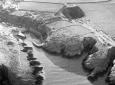
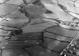
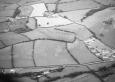
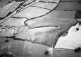
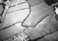
Summary : Pen Llwyn Roman fort is a Scheduled Ancient Monument (S.A.M.). The fort was first recognised on aerial photographs taken during the dry summer of 1976. Since then a number of small excavations have been undertaken by U.C.W. Aberystwyth. Cropmarks plotted from aerial photographs show a classic rectangular plan with its rounded corners aligned at the cardinal points of the compass. The most obvious surface indications are in the south corner where the line of the rampart is followed by the hedge bank boundary of a field, which also marks the break of slope; the field on the exterior being over a metre lower at this point. Internally the ground is uneven with knolls of higher ground. Excavations in the 1970s and 1980s revealed that the defences were of earth and timber with timber corner towers. Finds of black burnished ware pottery suggest an establishment date in the 70s AD at around the same time as the forts at Pennal, Trawsgoed and Llanio. The site straddles two pasture fields which have been used for arable (cereal and rootcrops) farming in the past. Grass leys are reseeded periodically. W.Steele 2006
Description : This Roman fort was identified from aerial photographic evidence. It is located on a ridge overlooking a point where the nearby roman road crosses the Afon Rheidol. It is aligned on a northeast-southwest axis, with the southern parts respected by field boundaries while the rest survives as cropmarks. The fort appears to have triple ditch defences with a double ditch annexe to the southwest.DS.27.10.2004
The site of a Roman fort, now very difficult to see in the field. It was excavated in the late 1970s and early 1980s. This established that it was demolished upon abandonment, but this was undated. There is only a small amount of pottery found, with a few sherds only dating to the period after 120AD. Presumably it was abandoned around the 120s AD.
 © DAT)