Dyfed Archaeological Trust Historic Environment
Record
Use
of this information is subject to the terms and conditions of access to
Welsh HER data published on DAT's website www.dyfedarchaeology.org.uk This information is supplied
for the purposes of personal interest only and may not be used as part
of a commercial project.
Please
contact the HER if you have any further questions regarding this information,
if you would like any of the sources followed up or if you have information
that could improve the record in any way. Primary Reference Numbers (PRNs)
should be quoted in any correspondence.
Grongaer
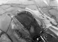
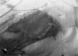
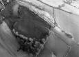
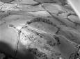
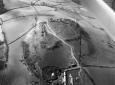
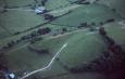
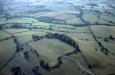
Primary Reference Number (PRN) : 704 Trust : Dyfed Community : Llangathen Unitary authority : Carmarthenshire NGR : SN57342160 Site Type (preferred type first) : Iron Age Hillfort Status : Scheduled Monument
Summary : On the summit of a hill, at approximately 140m above sea level, with fine views in all directions lies the roughly rectangular, univallate hillfort of Grongaer. It is defended by a bank that measures 1.1m high internally and 5m high externally, with a slight berm visible outside the bank indicating the probable position of the ditch. There are no other traces of a ditch. Two simple entrances are present: one on the southwest and another on the northeast.
The bank is best preserved on the short northeast and southwest sides. The natural steep slopes that exist to the northwest and the southeast defend the long sides of the enclosure, and here the bank is not so pronounced. The surface of the interior is irregular, and occasionally broken by outcrops of rocks, but there are no signs of internal features.
The interior of the fort is covered with short grass and is used as rough grazing; the banks are covered with grass with some gorse.
F Murphy 27 February 2008 - compiled from several sources
Sources :
, c1850 , Painting: The Towy Valley looking toward Dinefwr from Grongar Hill (Attributed to William Muller) c 1850
F Murphy, R Ramsey, M Page and K Murphy , 2008 , A SURVEY OF DEFENDED ENCLOSURES IN CARMARTHENSHIRE, 2007-08: GAZETTEER OF ORDNANCE SURVEY GRID SQUARES SN51, SN52, & SN54
, 1855 , Archaeologia Cambrensis ,
, 1893 , Archaeologia Cambrensis ,
, 1906-7 , TCASFC ,
, 1921 , TCASFC ,
CADW , 1986 ,
CADW , 1997 , AM107 ,
Eyre-Evans,G , 1918 , TCASFC ,
James,T , May 1984 , Ap84129,2312 ,
James,TA , 1978-9 , TAJ-AP-SN5721 ,
Jones,GDB , 1971 , Carmarthenshire.Ant ,
Lewis,S , 1833 , Topographical Dictionary of Wales ,
Murphy,K , 2004 , Assessment of Prehistoric Defended Enclosures 2004-5, Report No 2004-100 ,
Nash-Williams,VE , 1933 , Archaeologia Cambrensis ,
OS , 1906 , Carmarthenshire XXXIII4 ,
OS , 1968 ,
RAF , 1946 ,
RCAHM , 1917 , Carmarthenshire ,
Rees,SE , 1983 , Carmarthenshire.SAMs ,
Savory,HN , 1954 , Bulletin of the Board of Celtic Studies ,
St.Joseph,JK ,