Dyfed Archaeological Trust Historic Environment
Record
Use
of this information is subject to the terms and conditions of access to
Welsh HER data published on DAT's website www.dyfedarchaeology.org.uk This information is supplied
for the purposes of personal interest only and may not be used as part
of a commercial project.
Please
contact the HER if you have any further questions regarding this information,
if you would like any of the sources followed up or if you have information
that could improve the record in any way. Primary Reference Numbers (PRNs)
should be quoted in any correspondence.
Llandovery;alabum;loventium(?);tre-goch
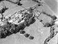
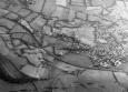
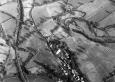
Primary Reference Number (PRN) : 4072 Trust : Dyfed Community : Llandovery Unitary authority : Carmarthenshire NGR : SN7695035214 Site Type (preferred type first) : Roman Fort Status : Scheduled Monument
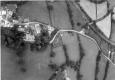
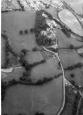
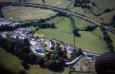
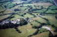
Summary : The Roman fort at Llandovery (Alabum?) was possibly established in the AD50s, based on ceramic and stratigraphic evidence.The fort is located on high ground immediately to the north of Roman road RR623 (PRN 3419). Parts of the northeast and northwest sides of the fort survive as earthwork banks in pasture, but much of the rest of the fort has been built upon.It appears to measure approximately 170m by 120m. A modern minor road runs through the fort, probably on the line of a Roman street. Following recent geophysical survey, there is evidence of a possible second fort, annexe or reduced fort on the same site. There is also evidence of a vicus (PRN 8505) running along the north side of the A483.DS.27.10.2004.

 © )
© )