Dyfed Archaeological Trust Historic Environment
Record
Use
of this information is subject to the terms and conditions of access to
Welsh HER data published on DAT's website www.dyfedarchaeology.org.uk This information is supplied
for the purposes of personal interest only and may not be used as part
of a commercial project.
Please
contact the HER if you have any further questions regarding this information,
if you would like any of the sources followed up or if you have information
that could improve the record in any way. Primary Reference Numbers (PRNs)
should be quoted in any correspondence.
St Anthony's Chapel
Primary Reference Number (PRN) : 35095 Trust : Dyfed Community : Angle Unitary authority : Pembrokeshire NGR : SM85150309 Site Type (preferred type first) : Early Medieval Cist Grave Cemetery / Medieval Cist Grave Cemetery Status : Pembrokeshire Coast National Park
Summary : A cist cemetery on the site of the churchyard (PRN 7595) associated with the documented medieval St. Anthony's Chapel (PRN 3092). Cist graves have been observed eroding from the cliff face, and aerial photographs show a low but distinct oval shaped earthwork bank in improved pasture. Dyfed Archaeological Trust carried out excavations at the site during the summers of 2005 and 2006 (PRNs 55789 & 56955). Evidence was revealed of a substantial rectangular enclosure surrounding an oval cemetery compound. The cemetery compound was defined by two phases, the earlier of which was radiocarbon dated to 660-870 AD at the latest. The compound enclosed numerous intercutting burials. Eight of these were cist burials. All but one were immature individuals, the exception contained both an adult and a neonate. One of the immature burials was dated to 720-920 AD, while the adult was dated to 900-1040 AD. HGW 2011
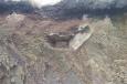
Description : Dyfed Archaeological Trust carried out excavations at the site during the summers of 2005 and 2006 (PRN 55789 & 56955). Evidence was revealed of a substantial rectangular enclosure surrounding an oval cemetery compound. The cemetery compound was defined by two phases, the earlier of which was radiocarbon dated to 660-870 AD at the latest. The compound enclosed numerous intercutting burials. Eight of these were cist burials. All but one were immature individuals, the exception contained both an adult and a neonate. One of the immature burials was dated to 720-920 AD, while the adult was dated 900-1040 AD. Apart from the burials within the oval cemetery compound, no further burials were encountered during the excavation. One of the cist burials eroding from the cliff face has been dated to 650-720 AD. This burial group appears to be contained within a substantial rectangular enclosure which was radiocarbon dated to 540-650 AD. An earlier geophysical survey (PRN 56982) had suggested the cemetery compound also contains a rectangular east-west aligned building (c. 5m x 6m) at its narrow (northeast) end, although it was not possible to confirm the presence of a building during the excavations. HGW 2011 based on Schlee 2006, 2008.
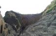
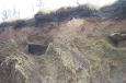
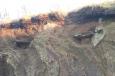
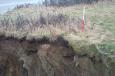
Graves are oriented east-west, suggesting an early Christian date. No mounds are apparent in the field or cliff,and there are no stones indicating the positions of the cists. Two cists are immediately apparent, with traces of a third, and all are being actively eroded out. Visited during PFRS fieldwork Feb 2003. N Cook PFRS 2004
Early medieval C site, ie. low-probability early medieval origins. Cist graves associated with St Anthony's Chapel (PRN 3092) and churchyard (PRN 7595). NDL 2002
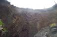
Two definite and one probable long cists were identified by Heather James on a visit to the site on 28th July. The graves were stone-lined and oriented. Grave 1 used the bedrock as a base. The southern side was not exposed but the northern side slab and capstone were visible. The remains of at least two skeletons were seen. Grave 2 lay 2m to the north of Grave 1. Both side slabs and part of a capstone were visible and again bedrock wwas used as a base. No bones were seen. The possible Grave 3 lay 2m to the north of Grave 2. Three large projecting slabs pitched against each other may have been the remains of a collapsed cist. JH April 1998 based on James,H 1997
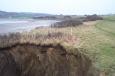
A cist grave was discovered by a member of the public in the cliff face above West Angle Beach on 24th July 1997. Up to four graves were subsequently identified within the eroding cliff face (extract taken from The Western Mail article Wed, 30th July 1997). BA & KM 1997

 © DAT)