Dyfed Archaeological Trust Historic Environment
Record
Use
of this information is subject to the terms and conditions of access to
Welsh HER data published on DAT's website www.dyfedarchaeology.org.uk This information is supplied
for the purposes of personal interest only and may not be used as part
of a commercial project.
Please
contact the HER if you have any further questions regarding this information,
if you would like any of the sources followed up or if you have information
that could improve the record in any way. Primary Reference Numbers (PRNs)
should be quoted in any correspondence.
Parc Y Meirw
Primary Reference Number (PRN) : 2551 Trust : Dyfed Community : Cwm Gwaun Unitary authority : Pembrokeshire NGR : SM9988935922 Site Type (preferred type first) : Bronze Age Stone Row Status : Pembrokeshire Coast National Park
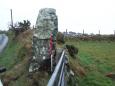
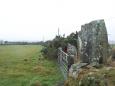
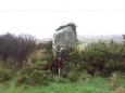
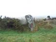
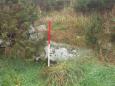
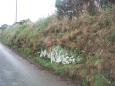
Summary : The remains of a stone row consisting of four uprights and at least two recumbent stones in the hedge bank dividing the pasture field from the road. The row is aligned northwest-southeast on ground which slopes down to the northwest. It is possible that a seventh stone, recumbent, which is visible in the hedgebank is also part of the stone row. RSR 2004.
Description : The remains of a stone row consisting of four uprights and at least two recumbent stones in the hedge bank dividing the pasture field from the road. The row is aligned northwest-southeast on ground which slopes down to the northwest. The most easterly stone (A) (NGR SM9991435904) is upright, situated to the east of the field gate, and is 2.7m high x 1m x 0.8m. Next stone (B) (NGR SM9989835913) is upright, situated on the west side of the field entrance, and is 2m high x 0.9m x 0.9m. Next stone (C) (NGR SM9988935922) is upright and measures 2.3m high x 1.7m x 0.8m. Next stone (CR) (NGR SM9986335925) lies recumbent in the hedge and is 2.4m long by 0.4m high. Next stone (D) (NGR SM9986035945) is upright and measures 2.3m high x 0.8m x 0.8m. The most westerly of the stones which definitely form the stone row,(E) (NGR SM9985535948), is recumbent and measures 2m long. A seventh stone (F) (NGR SM9980835972) lies recumbent in the hedgebank and can only be seen from the roadside, it measures 3.7m long x 0.9m high, but it is unclear whether or not it was originally part of the stone row. Generally the stones are in good condition and appear to be under no threat, although there has been some subsidence of the hedgebank on the road side which could ultimately undermine the stones. N Cook PFRS 2004

 © DAT)