Dyfed Archaeological Trust Historic Environment
Record
Use
of this information is subject to the terms and conditions of access to
Welsh HER data published on DAT's website www.dyfedarchaeology.org.uk This information is supplied
for the purposes of personal interest only and may not be used as part
of a commercial project.
Please
contact the HER if you have any further questions regarding this information,
if you would like any of the sources followed up or if you have information
that could improve the record in any way. Primary Reference Numbers (PRNs)
should be quoted in any correspondence.
Caer Argoed
Primary Reference Number (PRN) : 1996 Trust : Dyfed Community : Llangwyryfon Unitary authority : Ceredigion NGR : SN61627099 Site Type (preferred type first) : Iron Age Hillfort Status : Scheduled Monument
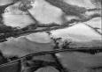
Summary : Lying on the summit of a rounded ridge at approximately 170m above sea level, Caer Argoed is a small hillfort. On the south side the land falls away steeply to the Afon Wyre 50m below, on other sides the slopes are gentler. The internal area of 0.43ha is irregularly shaped, approximating to a triangle and reflects the shape of the hill. It is defended by a univallate rampart standing up to 2m high and over 15m wide. The location of the entrance is unclear. A small rectangular annexe appended to the northwest side is defended by a single rampart except on the northwest side where it becomes bivallate. Aerial photographs show a cropmark ditch running roughly concentric and 50m from to the main enclosure on the northeast side. This may be an outer line of defence, or another annexe. The site is under improved pasture, with a little gorse scrub on the annexe banks. K Murphy 17 January 2006 - compiled from several sources.
Description : A polygonal hillfort, approximately 89 x 84m, occupying the rounded summit of a low ridge with the ground falling steeply away on the south side to the valley of the Afon Wyre. The single rampart is about 15m wide and stands more than 2m high. To the northwest is a rectangular annex appended to the hillfort, univallate on all but the northwest side where two ramparts and ditches have been built. Parchmarks on aerial photographs show an additional defence beyond the fort to the east, visible as an irregular palisade trench running for 107m from the edge of the promontory overlooking Cwm Wyre, around to the north side of the fort, effectively forming an additional annex below the fort. Parchmarks additionally show at least four pits, presumably rock-cut, within the main fort. The whole of the hillfort has been badly damaged by ploughing in the past. Anecdotal evidence on the field names kindly given by the landowner records the names `Y Gaer' for the field containing the main fort, `Fron Gaer' for the field containing the northwest (earthwork) annex, and `Domen Gaer' for the field immediately adjacent to the southwest angle of Fron Gaer, with its south side formed by Cwm Wyre. She noted that `Domen Gaer' was traditionally said to have been the site of the `mound' or rubbish tip of the main fort, this term commonly used nowadays to refer to muck heaps. T Driver 2004.
A sub-circular enclosure on a small hill with a well defended annexe to the north-west. JH based on Cadw 1993
Sources :
K. Murphy, R. Ramsey and M. Page , 2006 , A SURVEY OF DEFENDED ENCLOSURES IN CEREDIGION, 2006: GAZETTEER OF ORDNANCE SURVEY GRID SQUARES SN67
, 1936 , T.Card.AS ,
, 1994 ,
CADW , 1988 , AM107 ,
CADW , 1993 , AM107 ,
Cadw , 2000 , AM107 ,
Driver T , 2004 , Appendix 1 of thesis by T Driver ,
Hogg,AHA , 1962 , Bulletin of the Board of Celtic Studies ,
Hughes,IT , 1926 , T.Card.AS ,
Lewis,S , 1833 , Topographical Dictionary of Wales ,
Meyrick,SR , 1810 , History of Cardiganshire ,
Murphy,K , 2004 , Assessment of Prehistoric Defended Enclosures 2004-5, Report No 2004-100 ,
Musson,CR , 1992 , AP92-55.42 Location shot in dull light from NE ,
Nash-Williams,VE , 1933 , Archaeologia Cambrensis ,
OS , 1974 ,
RAF , 1950 ,
UCW Swansea , 1952 ,