Dyfed Archaeological Trust Historic Environment
Record
Use
of this information is subject to the terms and conditions of access to
Welsh HER data published on DAT's website www.dyfedarchaeology.org.uk This information is supplied
for the purposes of personal interest only and may not be used as part
of a commercial project.
Please
contact the HER if you have any further questions regarding this information,
if you would like any of the sources followed up or if you have information
that could improve the record in any way. Primary Reference Numbers (PRNs)
should be quoted in any correspondence.
Moel Trigarn; Foel Drycarn; Foel Drygarn
Primary Reference Number (PRN) : 1010 Trust : Dyfed Community : Crymych Unitary authority : Pembrokeshire NGR : SN15773360 Site Type (preferred type first) : Iron Age Hillfort Status : CL , Pembrokeshire Coast National Park , Site of Special Scientific Interest
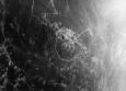
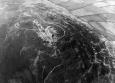
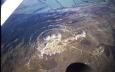
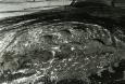
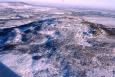
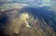
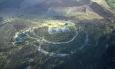
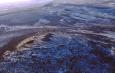
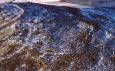
Summary : Moel Trigarn is a hillfort occupying the summit of a craggy, conical hill that rises to 360m above sea level. The main defensive circuit comprises two, widely-spaced, vegetation-covered, dilapidated stone-built banks with flanking ditches. On the south side the defensive circuit takes in a low cliff - there is no built defence here. On the other three sides the banks curve around the hilltop forming an oval inner enclosure c. 180m east-west and 120m north-south. The gap between the two banks is approximately 45m. The inner bank rises about 1m above the interior and 3m-4m above the ditch. It has largely collapsed into the ditch, obscuring much of it. The outer bank is slighter. Dry-stone walling facing is visible on the inner and outer face of the outer bank and in sheep scraps on the outer face of the inner bank. The outer bank runs up to meet the inner bank on the west side - here there is a simple entrance through the inner bank. There is also a simple entrance through the inner bank on the east side leading into space between the ramparts. A sub-rectangular annexe, 145m by 75m, is attached to the northeast side of the outer bank and is defined by vegetation-covered stony bank. The interior is domed, with the summit crowned by three massive cairns (hence the name) considered to be Bronze Age funerary monuments. Right across the hilltop, within the inner enclosure, the space between the ramparts and in the annexe, are numerous (perhaps over 200) circular platforms, probably house sites. Limited excavation by Baring Gould in 1900 revealed artefacts consistent with late prehistoric/Romano-British occupation.
The RCAHMW has undertaken a detailed survey of the site.
The site is under heather. It is frequently visited, but seems to be suffering little from visitor erosion. There is some damage the ramparts from sheep-scraps, particularly the inner one.
K Murphy 20 July 2006
Description : On 03/04/2024 A National Park Authority Heritage Volunteer identified a disturbance to the protected scheduled monument PE010 Foel Drygarn, See Threats child table for details.
A heritage crime was reported on March 20th 2023. Stones had been moved and more graffiti found scratched on the surface of the rockface. See Threats child table for details.
During a recent visit on 13/01/2023 to the scheduled monument known as PE010 Foel Drygarn Camp, heritage volunteers identified that a name had been scratched into the surface of a rockface on site. This is being reported as it is a heritage crime to a scheduled monument under 'OpHeritageCymru'. See Threats child table for description.
National Parks Authorities were notified in May 2022 of A large cross reported painted onto the rock face at the scheduled monument. Several items were also left at the scheduled monument. “These items were left included flowers and candles with one included an image of the Virgin Mary.” See Threats child table for description.
A heritage Crime report was made on 22nd January by Community Archaeologist for PCNPA regarding damage and disturbance of the scheduled monument. Evidence for rearrangement of the burial cairn, quarrying of the bluestone and building, using cairn stones, and burning of a campfire. See Threats child table for description.
Moel Trigarn is a hillfort occupying the summit of a craggy, conical hill that rises to 360m above sea level. The main defensive circuit comprises two, widely-spaced, vegetation-covered, dilapidated stone-built banks with flanking ditches. On the south side the defensive circuit takes in a low cliff - there is no built defence here. On the other three sides the banks curve around the hilltop forming an oval inner enclosure c. 180m E-W and 120m N-S. The gap between the two banks is approximately 45m. The inner bank rises about 1m above the interior and 3m-4m above the ditch. It has largely collapsed into the ditch, obscuring much of it. The outer bank is slighter. Dry-stone walling facing is visible on the inner and outer face of the outer bank and in sheep scraps on the outer face of the inner bank. The outer bank runs up to meet the inner bank on the west side - here there is a simple entrance through the inner bank. There is also a simple entrance through the inner bank on the east side leading into space between the ramparts. A sub-rectangular annexe, 145m by 75m, is attached to the NE side of the outer bank and is defined by vegetation-covered stony bank. The interior is domed, with the summit crowned by three massive cairns (hence the name) considered to be Bronze Age funerary monuments. Right across the hilltop, within the inner enclosure, the space between the ramparts and in the annexe, are numerous (perhaps over 200) circular platforms, probably house sites. Limited excavation by Baring Gould in 1900 revealed artefacts consistent with late prehistoric/Romano-British occupation.
The RCAHMW has undertaken a detailed survey of the site.
The site is under heather. It is frequently visited, but seems to be suffering little from visitor erosion. There is some damage the ramparts from sheep-scraps, particularly the inner one.
 © DAT)
 © )
© )